Our services


Troubleshooting, workflow optimization, and best practice recommendations for GIS professionals.

Using advanced techniques and tools, visualise, evaluate and predict outcomes.
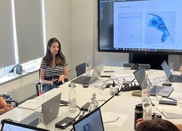
Tailored learning experiences for professionals, teams, and organizations, from beginner to advanced levels.
GIS Training
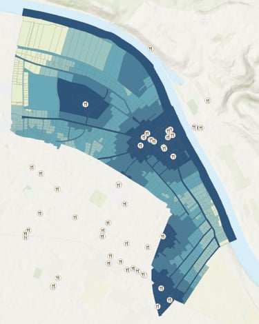
Spatial Analysis - Techniques for Urban Planning and Design Decision-Making
Informed decision-making in urban planning and design relies on multi-layered spatial analysis. Using advanced techniques and tools, stakeholders can visualise, evaluate and predict outcomes to create optimised, sustainable and user-centred urban environments.
These techniques can be applied at different project stages:
Pre-Planning: Feasibility studies, environmental assessments, and site selection.
During Planning: Impact analysis, visualization, and optimization.
Post-Design: Performance evaluation and monitoring.
Below you'll find examples of the services and tools available for comprehensive spatial analysis taylored to your project's needs.
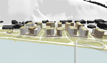
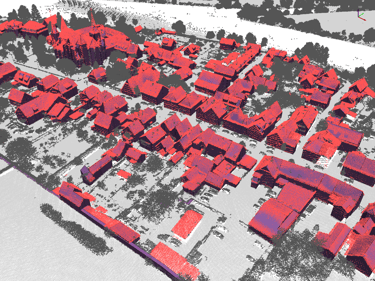
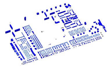
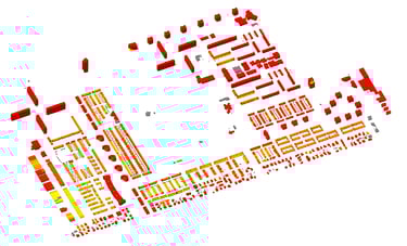
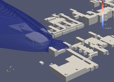
3D Modeling, Reconstruction, Analysis & Visualization
The 3D cartographic is an effective way to communicate about the built environment. Georeferenced datasets, including point clouds, DEMs, and vector GIS layers, are combined to generate informative visuals. Moreover, they enable spatial analysis, such as visibility and shadow studies. Outputs are optimized for use in GIS, BIM, and 3D visualization platforms.
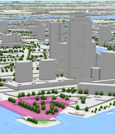
3D Reconstruction:
Point cloud data can be processed to generate an accurate, watertight 3D surface model of the built environment. The resulting model represents a LoD2.2 level of detail, suitable for urban design, architectural context analysis, environmental simulations, and impact assessments. See more here.
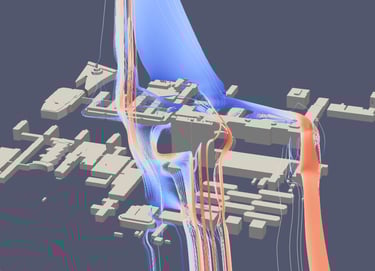
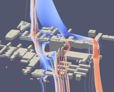
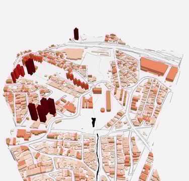
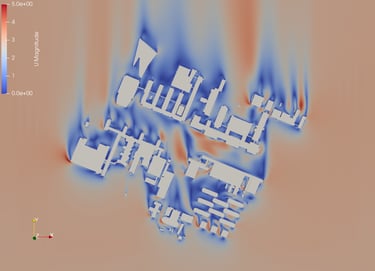
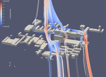
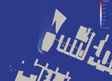
Urban Wind flow & Pollution dispersion modelling
We use CFD to transform complex urban aerodynamics into design decision support tools. First, we simulate pedestrian-level wind, turbulence, pressure, and pollutant plumes for alternative massings. Then, we help pinpoint ways to reduce wind discomfort and accelerate dilution.
Test scenarios (heights, setbacks, screens, trees, corridors) before you build.
Identify hotspots and quantify Key Performance Indices e.g. at pedestrian level (wind speed, k, ε, concentration).
Compare A/B designs with maps, glyphs, streamtraces, and 3D plume visuals.
Get evidence-based guidance to optimize building form and public-realm comfort.
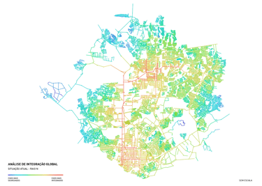
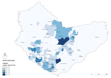
Geospatial Analytics
Mobility analysis:
Space Syntax: Identifying connected segments, visibility analysis to identify movement patterns, accessibility, and potential user flows.
Centrality Measures: Evaluating key urban spaces using:
Closeness Centrality: Proximity to all other nodes.
Betweenness Centrality: Frequency of paths crossing through a node.
Eigenvector Centrality: Influence of a node based on connections.
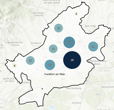
Shortest Path Calculations: Optimizing routes for pedestrians, cyclists, and vehicles.
Network Allocation: Determining service catchments based on available resources and user locations.
Isochrone Mapping: Defining areas reachable within specific time intervals.
Nearest Neighbors Analysis: Understanding proximity relationships for facilities and services
Energy Demand & Solar Analysis
Shading analysis for building or open spaces orientation and placement.
Solar irradiance calculations for energy efficiency studies.
Sun direction assessments for daylight optimization and thermal comfort.
Urban cooling & Heating demand.
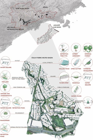
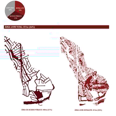
Topographic Analysis
Generation of Contour lines for elevation visualization.
Slope analysis for construction feasibility, route planning (cycling routes) or drainage planning.
Visibility analysis to evaluate sightlines and viewpoints.
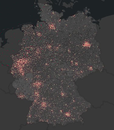
Clustering & Pattern Recognition
Identifying hotspots and activity centers in urban environments.
Spatial clustering for market segmentation and service distribution planning.
Map Algebra & Raster Analysis
Custom calculations to assess spatial phenomena.
Remote Sensing
Land cover classification.
Software Capabilities
GIS Platforms: ArcGIS Pro, QGIS, GRASS and other open-source alternatives.
Custom Development: Automating workflows and creating specialized tools using Python-Packages, C++ for routine or bespoke analysis.
ArcGIS Pro & QGIS Training: Tailored learning experiences for professionals, teams, and organizations, from beginner to advanced levels.
Customized Training Programs: Training sessions developed to address your organization’s specific challenges and project needs.
Hands-On Learning: Practical exercises and real-world scenarios to ensure participants gain actionable skills.
Training Services
GIS Training
GIS Support
GIS Support Services
On-Site or Remote Guidance: Comprehensive support for urban design and planning projects using advanced GIS tools and methodologies.
GIS User Assistance: Troubleshooting, workflow optimization, and best practice recommendations for GIS professionals.
GIS Strategy Development: Creating a roadmap for implementing or expanding GIS capabilities.


Reviews
"I have known Mrs. Carmem Aires both as a colleague and a freelancer for over four years. Working with her has always been a pleasure in both roles. Mrs. Aires combines excellent software skills, extensive urban planning knowledge and strong visual abilities. Her work is efficient and of high quality. She approaches challenges in a solution-oriented manner and gives her best to achieve project goals. On a personal level, Mrs. Aires’s communicative and easygoing personality facilitates smooth project flow. I am glad to have worked with her over the past few years and highly recommend her for urban planning or GIS-based projects."
Dr. Mustafa Obaid, Chair of Urban Management, Institute of Urban Planning, Technical University of Cottbus-Senftenberg"
"Carmem has a great understanding of how GIS works and what you can achieve with it in your business. Her teaching skills in dealing with people with different levels of knowledge were exceptional. All participants were able to follow the content and apply what they learned in their daily work. She answered all participants' questions in a professional and understandable way. She also proved to be very flexible in planning the training and showed a lot of enthusiasm and motivation, which was transferred to the participants. We look forward to further support from her in the future."
Christian Hübner, Urban Planning Team Coordinator, AS+P Frankfurt
Consulting
Expert GIS Solutions for Urban Design and Planning.
KvK: 94578486
Rotterdam NL
contact
info@urbispatium.com
© 2025. All rights reserved.